

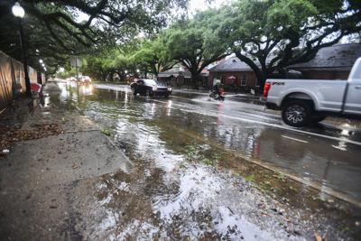
Lafayette is expected to see severe weather moving through the area starting Wednesday, according to National Weather Service forecasters.
Meteorologist Nick Slaughter with the National Weather Service in Lake Charles said things are expected to stay active until the weekend with the possibility of damaging winds and hail.
"There's also a risk for flash flooding due to the heavy rain, and a level one out of four marginal risk which covers the Lafayette area for Wednesday into Friday,” Slaughter said.
Beginning Tuesday, a slight chance of showers and thunderstorms is forecasted and going into Tuesday night, showers and thunderstorms could occur after 10pm.
Heading into Wednesday, there is a marginal risk for severe weather after 7 a.m. Severe weather occurs when winds are over 60 mph causing damage and hail is 1 inch in diameter or larger, according to Slaughter. The chance of precipitation on Wednesday is 80% with rainfall amounts between three quarters and one inch. Showers and thunderstorms will likely continue into Wednesday night with lows around 71.
On Thursday, showers and thunderstorms are forecast with a high near 86 and partly sunny skies. The chance of precipitation is 70%. Thursday night, there's a 40% chance of showers and thunderstorms after 1 a.m.
"Friday is still not clear with a chance of precipitation being 60%, but Friday night going into Saturday things should be cleared out," Slaughter said.
Saturday and Sunday highs will be in the mid 80s with lows around 68.