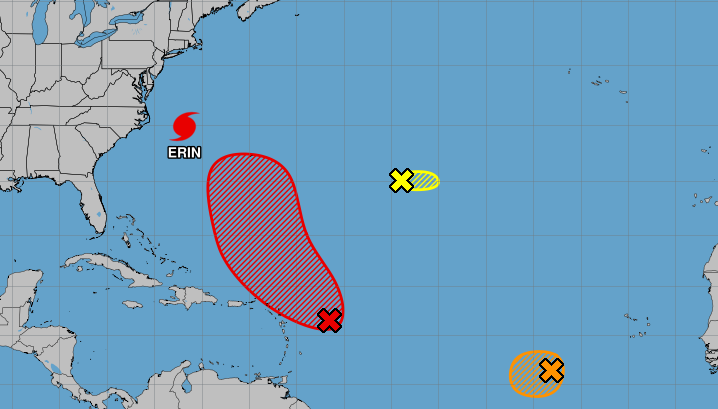
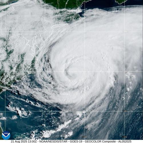
Forecasters highlighted a third disturbance in the Atlantic Ocean Thursday morning as Hurricane Erin made its closest approach to the U.S., bringing continued tropical storm conditions to North Carolina and Virginia.
The Atlantic hurricane season is in its peak period of activity, and a small area of low pressure is the latest disturbance to crowd the tropics.
Located about 1,200 miles southwest of the Azores, the system was producing limited showers and thunderstorms as of 7 a.m. Thursday, according to the National Hurricane Center.
Weather conditions were only marginally conducive to development as the system moved east away from the U.S., and forecasters said gave it a 30% chance of forming into a tropical depression or storm within the next two days.
The disturbance is not a threat to Louisiana, and State Climatologist Jay Grymes said Thursday morning that tropical activity is not expected in the Gulf for at least the next seven days.
Hurricane Erin moves east
North Carolina remained under a state of emergency Thursday as heavy rains, storm-surge flooding and winds pounded the Outer Banks, NHC forecasters said.
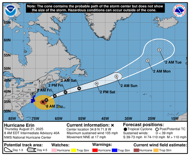
While Erin is not a threat to Louisiana, Virginia and North Carolina will get drenched over the next several hours and the Mid-Atlantic and southern New England regions are likely to experience tropical storm-force winds through Friday. Weather advisories are in effect across the region.

Beaches across the East Coast remained closed Thursday after NHC forecasters said beachgoers should avoid swimming "at most U.S. East Coast beaches" due to life-threatening surf and rip currents.
As of 7 a.m. Thursday, Erin was 210 miles east of Cape Hatteras, North Carolina, and was moving north-northeast at 17 mph. The hurricane was producing maximum sustained winds of 105 mph with wind speeds expected to gradually slow.
Forecasters said the hurricane is set to move further east away from the U.S., weakening through the end of the week. The NHC's latest forecast track shows Erin devolving to a significantly weakened post-tropical cyclone by Sunday, but forecasters said it could happen sooner.

Click here to find a full list of watches and warnings related to Hurricane Erin.
Tropical wave keeps north
A tropical wave near the Leeward Islands is expected to continue moving north, NHC forecasters said Thursday morning. It is expected to develop into a tropical depression or storm this weekend.
As of 7 a.m. Thursday, the system had a 70% chance of forming within the next week and a 40% within the next 48 hours.
Grymes, the state climatologist, said that while the system does not pose a threat to the U.S. East Coast, it could be a problem for Bermuda.
If a storm does form, it would be called Fernand and would mark the sixth named storm of the 2025 Atlantic hurricane season.
Tropical wave off west coast of Africa
Another tropical wave located west-southwest of Cabo Verde showed some signs of development, but it lacked a defined center, forecasters said Thursday morning.
The system could still become a short-lived tropical depression within the next day or so as it moves southwest across the Atlantic at about 15 mph. But forecasters expect further development to be put to a halt by hostile environmental conditions at the end of the week.
As of 7 a.m. Thursday, the system had a 40% of forming in the next 48 hours.


