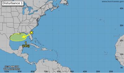
A low pressure system off the southeast coast of the U.S. is expected to move through the Gulf of Mexico toward Louisiana in the next day or two, but has a low chance of developing into the next named tropical storm.
While the disorganized system could bring heavy rain to parts of Florida and the Gulf Coast within the next few days, forecasters with the National Hurricane Service give it a 10% chance of forming within the next week as of 7 a.m. Wednesday.
The system mirrors a low pressure system that crossed into the Gulf and Louisiana last week. It brought flood advisories and downpours to much of south Louisiana.
The current system is right off the coast of northern Florida as of Wednesday morning. It is projected to move west-southwest into the north-central portion of the Gulf, where slow development is possible, forecasters said.
The system is likely to move inland by the weekend, ending its chances of development, according to NHC forecasters.
Rain is likely to be the biggest impact for Louisiana. While rain chances will tick up starting Wednesday afternoon through the evening, the latest forecasts show that rain is highly likely to hit the region Thursday and showers are likely across southeast Louisiana into the weekend.
National Weather Service meteorologist Hannah Lisney said Tuesday that the rain totals are expected to be smaller than last week's storms and the rain should help damp down dangerously high temperatures later this week.

