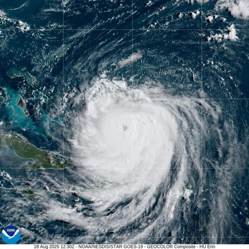
Hurricane Erin continued to grow and strengthened to a Category 4 hurricane again while a tropical wave over the eastern tropical Atlantic could further develop into a depression, forecasters with the National Hurricane Center in Miami said.
After Erin weakened to a Category 3 Sunday when its inner eyewall collapsed as its winds and circulation became increasingly powerful, there were some indications that Erin again had an eyewall as of 4 a.m. Monday when it was east of the Bahamas, NHC forecasters John Cangialosi said.
Hurricane Erin
Erin looked likely to continue strengthening Monday, but will likely slow at night due to some increase in shear and a broadening of the inner core wind field.

Erin could begin weakening Tuesday, but it is expected to remain a powerful hurricane through the week, Cangialosi said.
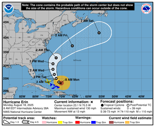
Erin was traveling west-northwest Monday morning, but it is expected to begin traveling north Monday night and Tuesday. The hurricane's core is expected to be in the middle of Bermuda and the east coast of the U.S. Wednesday and Thursday.
Erin was located about 115 miles north northeast of Grand Turk Island with maximum sustained winds of 130 mph Monday morning. It was moving northwest at about 13 mph.
Maximum winds could be up to 145 mph in the late afternoon or early evening.
On Saturday, Erin underwent rapid intensification and became a Category 5 hurricane. Rapid intensification is defined as an increase in maximum winds of at least 35 mph in 24 hours.
The southeast Bahamas and the Turks and Caicos Islands will likely experience tropical storm conditions for the next several hours as they felt the impact of Erin's outer rainbands, forecasters said.
As Erin's wind field grows this week, much of the western Atlantic should experience rough ocean conditions. Life-threatening surf and rip currents are expected along the beaches of the Bahamas, U.S. east coast, Bermuda, and Atlantic Canada
Residents of the Outer Banks of North Carolina and Bermuda are at risk of strong winds.

Tropical wave
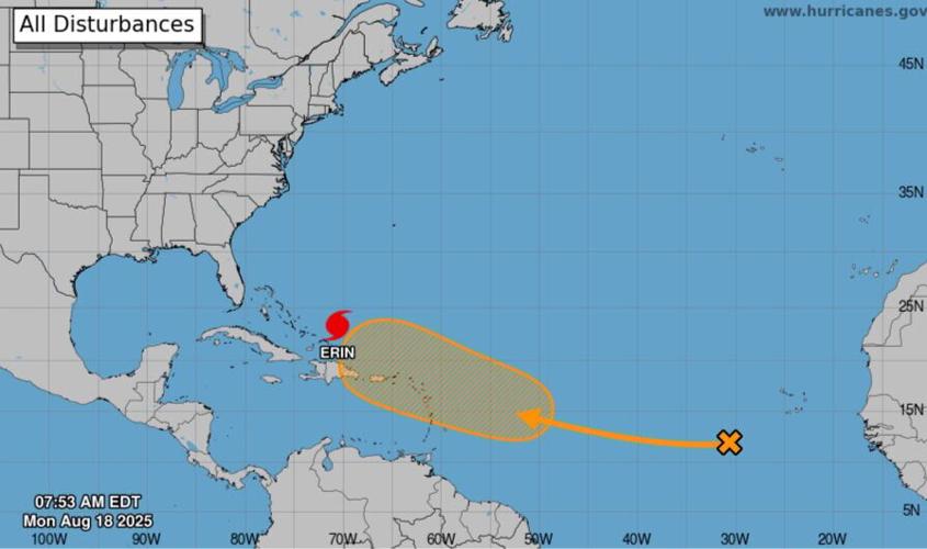
The wave over the middle of the east Atlantic continued to produce disorganized showers and thunderstorms. It was moving west-northwest across the Atlantic as of 7 a.m. Monday, according to the NHC.
Forecasters first highlighted the wave Saturday night, after Erin exploded in strength.
The environmental conditions seemed conducive for gradual development and forecasters said the system could become a depression during the latter part of the week.
The system's path may be similar to Erin's but it could be closer to the Leeward Islands, WAFB meteorologist Steve Caparotta said Monday.
"It's too soon to say if it will recurve like Erin or if there may eventually be any U.S. threats," Caparotta said.
Forecasters gave it a 50 percent chance of forming into a tropical depression or storm within the next seven days.
Don't miss a storm update this hurricane season. Sign up for our weather alerts newsletters here. Follow our Hurricane Center Facebook page here.


