


Beaches across the U.S. East Coast were closed Wednesday as Hurricane Erin's outer bands threatened to bring tropical storm conditions to North Carolina and two other disturbances showed potential for development.
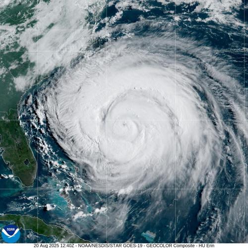
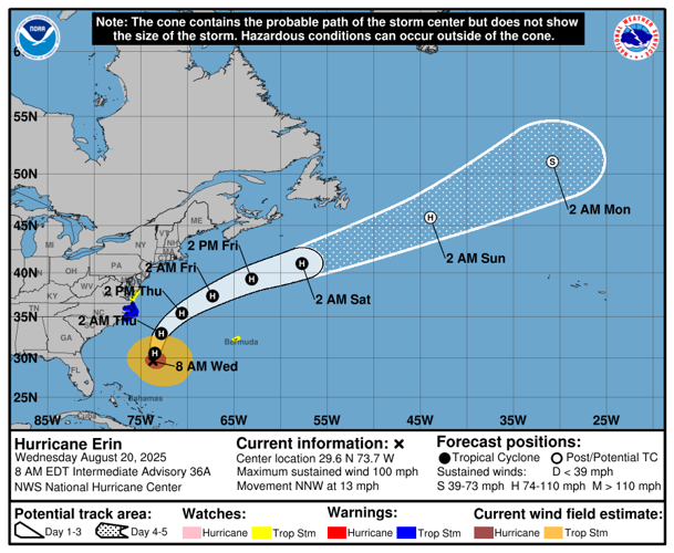
While Erin remained a Category 2 hurricane with sustained winds of 100 mph Wednesday morning, the storm's "larger than average" wind fields are expected to bring rising waters, flooding, heavy rain and high winds to the North Carolina Outer Banks and Virginia this week, forecasters with the National Hurricane Center in Miami said at 7 a.m.
While Erin is not a threat to Louisiana, advisories are in effect in portions of North Carolina, Virginia and Bermuda, and NHC forecasters said Wednesday that beachgoers should avoid swimming "at most U.S. East Coast beaches" due to life-threatening surf and rip currents.
North Carolina declared a state of emergency Tuesday with local declarations for Dare and Hyde counties and mandatory evacuations for Ocracoke and Hatteras islands.
In the northeast, beaches in states like New York and Massachusetts were ordered closed.
As of 7 a.m. Wednesday, Erin was 400 miles south-southeast of Cape Hatteras, North Carolina, and was moving northwest at 13 mph. While forecasters said Erin could maintain its strength and even intensify some this week, it will likely be significantly weakened by Saturday.

Click here to find a full list of watches and warnings related to Hurricane Erin.
Tropical wave to turn north
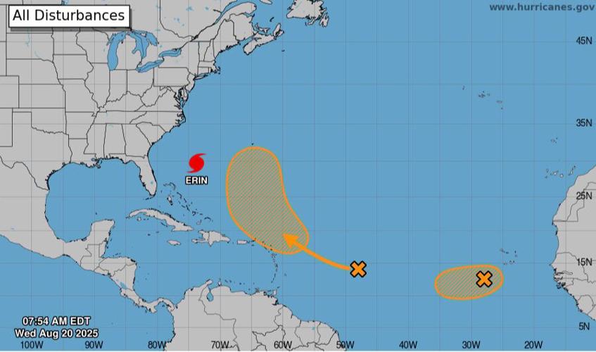
A tropical wave near the Leeward Islands that NHC forecasters have tracked for days is expected to turn north away from the U.S. later this week, forecasters said Wednesday morning.
Louisiana State Climatologist Jay Grymes said the wave could reach conditions favorable for development later this week, and NHC forecasters said it could form into a tropical depression or storm by the weekend.

Grymes said the system is not a threat to mainland U.S., but could be dangerous for Bermuda.
NHC forecasters gave the wave a 60% chance of becoming a tropical depression or storm in the next week as of 7 a.m. Wednesday, and a 10% chance in the next two days.
If a storm does form, it would be called Fernand and would mark the sixth named storm of the 2025 Atlantic hurricane season.
Wave off the west coast of Africa
Another tropical wave was southwest of Cabo Verde Wednesday morning, and forecasters said it could become a short-lived tropical depression in the coming days as it moves west across the Atlantic at about 15 mph.
However, forecasters said further development will likely be thwarted by harsh environmental conditions later this week.
As of 7 a.m. Wednesday, the storm had a 40% of developing into a tropical depression or storm within the next 48 hours.