
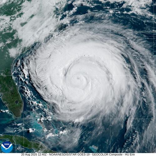


Most hurricanes that go down in history are remembered for the devastation they bring. But with little to no chance of hitting land, Hurricane Erin will be remembered for something else: its size.
With a massive wind field that had grown to roughly the size of Texas by Thursday morning, Erin is among the largest Atlantic hurricanes ever recorded. And while the monster storm is mercifully forecast to avoid land, Erin's bands are so vast that it sparked evacuation orders and beach closures along the U.S. East Coast this week, hundreds of miles from the center of the storm.
"It's big," LSU hurricane researcher Jill Trepanier said. "It's going to keep getting bigger."
Size and intensity, just to be clear, are not the same when it comes to hurricanes.
While Erin had weakened to a Category 2 storm with sustained winds of 100 mph by Thursday morning, National Hurricane Center forecasters said it remained a "sprawling" and unusually large storm.
As of 4 p.m. Thursday, hurricane-force winds extended 105 miles from Erin's eye, and its tropical storm-force winds had even more reach, stretching 320 miles from the storm's center.
That puts Erin in the top 10% largest storms of a similar intensity and location, according to the NHC.
Hurricane Katrina, though located in the Gulf, had hurricane-force winds that stretched about 105 miles from its center and tropical storm-force winds that reached as far as 230 miles when it hit Louisiana as a Category 3 storm, according to the National Weather Service.
Though Erin is not a threat to Louisiana or the Gulf Coast, Trepanier said it's a good reminder that wind speeds and categories aren't everything. The larger a storm, the more widespread its wind damage, storm surge and heavy rains.
The eye of Hurricane #Erin filmed from space 1 hour ago 🌪️#HurricaneErin pic.twitter.com/JyzXE5NXFY
— sen (@sen) August 20, 2025
How did Erin get so big?
Shortly after Erin formed as the Atlantic's first hurricane of 2025, it exploded in strength, rapidly intensifying from a tropical storm to Category 5 hurricane in a day.
Hurricanes can only sustain such intensity for so long before collapsing in on themselves, Trepanier said, and that's exactly what happened to Erin.
Last night, the 53rd Weather Reconnaissance Squadron flew into the eye of Hurricane Erin—and captured imagery of the breathtaking stadium effect.
— Hurricane Hunters (@53rdWRS) August 16, 2025
These missions provide critical data to the NHC to improve forecasts, helping keep communities safe before the storm makes… pic.twitter.com/RpAs7yMDRf
A hurricane's rotation is like that of a figure skater: In the same way a figure skater spins faster as she pulls her arms close to her body, compact storms with small eyes produce higher wind speeds.
But the faster a storm spins, the narrower its eyewall becomes, sometimes forcing it to collapse and weaken. And like how a spinning figure skater slows as she extends her arms, a weakening hurricane often spreads itself out and grows in size.
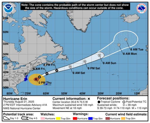
With nothing but warm water in its path, Erin was granted the opportunity to gain strength and size, spreading far and wide over the Atlantic. The storm is forecast to continue moving northeast along the East Coast in the coming days, bringing dangerous surf and rip currents to much of the region before deteriorating out at sea this weekend.
It'll be slow to lose strength because of it's size, NHC said.
"It's the real estate," Trepanier said, explaining that storms unobstructed by land have all the room they need to grow.

How does Erin compare?
Miami-based meteorologist and hurricane specialist Michael Lowry wrote on social media this week that Erin is "one of the biggest and most powerful" hurricanes ever to traverse the Atlantic so close to the East Coast.
Going back to 1966, only nine other Category 3 Atlantic hurricanes have had diameters longer than Erin's at Cat 3 strength, according to Lowry, including Irma in 2017, Wilma in 2005 and Betsy in 1965. There are a variety of strategies scientists use to measure the size of a hurricane, but Lowry said he measured storms' diameters based on the reach of their tropical storm-force winds.
A lot of folks asking how Erin's large wind field compares to other Atlantic hurricanes. There are lots of ways to slice it, but using tropical storm force wind diameter, here's how the forecast ranks for all Atlantic hurricanes and Atlantic majors (Cat 3+) only (since 1966). pic.twitter.com/oRpvi9mGu9
— Michael Lowry (@MichaelRLowry) August 20, 2025
Derek Thompson, a climatology research associate at LSU, said there have been 156 named storms with tropical storm-force winds reaching about as far as Erin's since 1988, including Tropical Storm Nadine and Hurricane Ernesto last year. More than 40 storms have had hurricane-force winds stretch as far as Erin's since 1988, including Hurricane Bill in 2009.
Thompson warned that his data could include systems that had completed extratropical transition, and he said reliable size data — with size defined as the radius of tropical storm-force, damaging, and hurricane-force winds — really only goes back to 2004.
But no matter how you slice it, Thompson said Erin's size, particularly for a storm of its intensity, is out of the ordinary.